Valleys and Mountains
Autumn Cruise
October 8, 2011
Date: 10/08/2011
General
Saturday, October 8th at 10:00 am, sharp, we’re off! Check below for departure point and driver’s
meeting time.
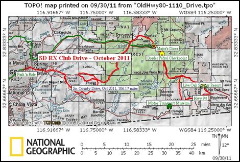 This drive is just less
than 110 miles. That does
not count the time / distance getting to the start or returning home from the finish. We will start at the La Mesa Park & Ride
and wind up at Major’s Diner in Pine Valley. We’re heading out from La Mesa
through Lyons Valley, Pine Valley and Cottonwood Valley. Then follow Hwy 94 and
back along Hwy 80. Along the way we will
stop at the Motor Transport Museum (MTM). Be sure to check out the web site here. We have done this route a few times, but
have not stopped in at the MTM in a while.
This drive is just less
than 110 miles. That does
not count the time / distance getting to the start or returning home from the finish. We will start at the La Mesa Park & Ride
and wind up at Major’s Diner in Pine Valley. We’re heading out from La Mesa
through Lyons Valley, Pine Valley and Cottonwood Valley. Then follow Hwy 94 and
back along Hwy 80. Along the way we will
stop at the Motor Transport Museum (MTM). Be sure to check out the web site here. We have done this route a few times, but
have not stopped in at the MTM in a while.
There
are several options for lunch, so the group can decide. Likely places will be Live Oak Springs Resort
or Major’s Diner.
Bring GMRS
/ FRS radios, w/ privacy codes, if you have them. It is much easier to keep in touch. There will be times for breaks and fuel
stops.
Departure
is as noted below and is where we met the last time, as well as 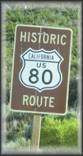 for other drives. It
is just west of where Hwys 94 and 125 intersect.
for other drives. It
is just west of where Hwys 94 and 125 intersect.
Departure Point
Directions
to departure point:
La Mesa Park ‘n Ride
Lot 8: La Mesa 91941 (43)
7675 High St
Route 94 at Lemon Grove Ave (NORTH side of
freeway)
http://www.dot.ca.gov/dist11/departments/planning/pages/parkride.htm
Driver’s
meeting
at 9:45 AM
Depart at 10:00 AM
 If you have any questions, drop me a note or post on the rx7club.com forum, in the
appropriate thread. Search for “San
Diego” and then look up the Scenic Drive thread.
If you have any questions, drop me a note or post on the rx7club.com forum, in the
appropriate thread. Search for “San
Diego” and then look up the Scenic Drive thread.
whodatRX7 (John)
Silver ’88 GTU
gtu88rx-drive <at> yahoo <dot> com